Why a River Valley Makes a Natural Route Through a County
A river valley can reveal the likely sequence of places on a county map, helping you trace a route while spotting where slopes and crossings change it.
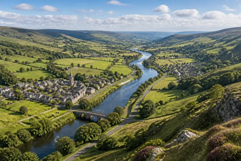
A river valley gives you a useful first line to follow across a county map. Its shape can connect the river, settlements and roads into a likely sequence of places, but the valley is a guide to the map, not a promise that every journey follows the water.
What does a valley show on the map?
Start with the river’s direction. Then look for the lower ground on either side, using contour lines, shaded relief or a topographic map. Contour lines bend into V shapes where they cross a stream; the points of the Vs generally face uphill, helping you distinguish the valley floor from the rising slopes.
On a county map, the valley may appear as a broad corridor rather than a narrow channel. Tributary streams feed into the main river, so smaller valleys branch from it like side routes. Notice these joins: they often explain why a road or a place lies where two lines of movement meet.
Keep the map’s scale in mind. A small-scale county map may simplify bends and side valleys, while a detailed Ordnance Survey map can show the terrain more clearly. Use the overview to see the county-wide direction, then inspect a larger-scale map when a gap between places seems puzzling.
How can you read the sequence of places?
Trace the valley from one end of the county to the other and mark settlements in order. A town near a tributary junction may sit at a natural meeting point; another may occupy a broader, flatter stretch of the valley floor. The order on the map is more informative than assuming the largest place must be the route’s starting point.
Check what lies between the settlements. A close-set run of places may follow a gentle valley floor, while a longer gap may coincide with a steep-sided reach, a marshy stretch or a section where the river cuts away from the road. The terrain suggests questions to investigate; it does not, by itself, explain when or why a settlement grew.
Say you are tracing a fictional county from its western edge. A small town sits where a side stream joins the main river, and two villages follow downstream on the same broad valley floor. On the map, you could mark the town first, then the villages, and check whether the road keeps to the low ground between them. The expected result is a clearer sequence to compare against the actual road network—not proof that the valley is the only or fastest way through.
Where does the valley stop being a straightforward route?
A river bends, narrows or changes level. A road may leave the valley to avoid a tight bend, reach a bridge or take a gentler gradient over a ridge. Look for contour lines crowding together: they indicate steeper slopes, which can make a direct-looking route less plausible than a longer line through easier ground.
Crossings deserve particular attention. Rivers constrain where roads can pass, but bridges, fords and modern road crossings do not necessarily occupy the same point. A bridge symbol, road junction or change in road direction can show where the route meets the river. Don’t infer a crossing from the river’s presence alone; check the map symbols and, where relevant, current mapping.
A railway may use a valley for part of its course and then cut through a ridge or follow a different corridor. Likewise, a major road may prioritise a direct connection between towns rather than hugging the river. Compare route lines with the contours instead of treating every transport corridor as a trace of the valley floor.
What can you learn from the valley’s shape?
A broad floor offers room for roads, buildings, fields or floodplain; a narrow valley leaves fewer obvious corridors. Where a tributary opens a side valley, a road may turn inland or a settlement may face more than one direction of movement. These are map-reading clues, not fixed rules: check the ground form at each place rather than assigning the same explanation to every town.
Relief shading can make the larger pattern easier to see, particularly where contour lines are dense. Compare it with a river layer and a road map, keeping the same area in view. If the river, low ground and road broadly align, the valley is helping organise your reading. If they diverge, note where and look for a ridge, crossing or change in gradient that could account for the difference.
- Mark the main river’s course before adding roads.
- Note tributary junctions and the settlements beside them.
- Use contour spacing to spot steep valley sides and easier ground.
- Check bridges and junctions where a road meets the river.
- Record stretches where the road leaves the valley, rather than forcing it into a river-following pattern.
How should you compare the valley with other routes?
Read the river valley alongside ridgelines, passes and the road network. A ridge can divide neighbouring catchments, while a low pass may offer a route across higher ground. County roads may connect places across these features without following the river for long. The valley helps explain one directional pattern; the wider map shows the alternatives.
For a quick comparison, choose two settlements and trace both the valley corridor and the mapped road between them. See whether the road follows the river, crosses a tributary or climbs out of the low ground. On a paper map, use a pencil; in a mapping app, switch between terrain and standard map views. Keep the county outline visible so you can see where the route enters and leaves the area.
Which map questions help you read a river valley?
Does a road beside a river always follow the valley floor?
No. It may follow a terrace above the river, skirt a bend or use a crossing that changes its course. Compare its line with contour spacing and the river’s position.
Why might a settlement sit away from the river?
It may occupy higher or flatter ground near a tributary, or stand on a slope above the valley floor. Check the contours around the settlement rather than assuming it should be directly beside the water.
Can a valley point towards a route outside the county?
Yes. Rivers and low ground continue beyond county boundaries, so the valley’s direction may connect with places in a neighbouring county. Follow the terrain across the boundary on the map before treating the county edge as the end of the route.
Which map should you use to check the terrain?
A topographic map with contour lines is useful for slopes and valley shape; a relief view can make broad landforms easier to recognise. Use a road map or mapping app to compare those features with current routes.
When reading a county map, treat the river valley as a way to organise the sequence of places: follow its direction, note where branches meet it, and check how roads respond to slopes and crossings. That approach makes a river valley route easier to see without mistaking a landform for the county’s only line of travel.